Fil:TTPI-locatormap.png
Ingen høyere oppløsning tilgjengelig.
TTPI-locatormap.png (326 × 225 piksler, filstørrelse: 11 KB, MIME-type: image/png)
| Denne filen er fra Wikimedia Commons og kan brukes av andre prosjekter. Informasjonen fra filbeskrivelsessiden vises nedenfor. |

|
Dette bildet bør gjenskapes med hjelp av vektorgrafikk som en SVG-fil. Dette har flere fordeler, se Commons:Media for cleanup for mer informasjon. Hvis en SVG-fil med dette bildet er tilgjengelig, vennligst last den opp. Etter opplasting erstatt denne malen med {{vector version available|nytt bilde.svg}}.
|
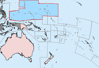
| Beskrivelse |
Čeština: Mapa poručenského území Tichomořských ostrovů.
English: This is a locator map of the former Trust Territory of the Pacific Islands (TTPI). |
||||||||
| Kilde | The map is based off of a locator map of Palau found on the German Wiki at de:Bild:Palau-Pos.png; it was created by German Wiki user de:Benutzer:Tzzzpfffand licensed under the GFDL. The changes made from the original map are various. The current boundries of the CNMI, Palau, FSM, and RMI are merged and Guam has it's own boundary due to the fact it never was a part of the TTPI. Boundries have been compared with Image:MapofTTPI.gif for accuracy. As the orginial image was licensed under the GFDL, I place my modification of the orginial map under the GFDL as well. | ||||||||
| Opphavsperson |
|
||||||||
| Tillatelse (Gjenbruk av denne filen) |
|


Filhistorikk
Klikk på et tidspunkt for å vise filen slik den var på det tidspunktet.
| Dato/klokkeslett | Miniatyrbilde | Dimensjoner | Bruker | Kommentar | |
|---|---|---|---|---|---|
| nåværende | 17. jun. 2010 kl. 03:27 | | 326 × 225 (11 KB) | Ras67 | cropped |
| 19. nov. 2006 kl. 16:52 |  | 330 × 228 (14 KB) | Electionworld | == Summary == This is a locator map of the former Trust Territory of the Pacific Islands (TTPI). The map is based off of a locator map of Palau found on the German Wiki at de:Bild:Palau-Pos.png; it was created by German Wiki user [[:de:Benutzer:T |
Filbruk
De følgende 2 sidene bruker denne filen:
Global filbruk
Følgende andre wikier bruker denne filen:
- Bruk i ar.wikipedia.org
- Bruk i ast.wikipedia.org
- Bruk i azb.wikipedia.org
- Bruk i az.wikipedia.org
- Bruk i be.wikipedia.org
- Bruk i bg.wikipedia.org
- Bruk i ca.wikipedia.org
- Bruk i cs.wikipedia.org
- Bruk i da.wikipedia.org
- Bruk i de.wikipedia.org
- Bruk i en.wikipedia.org
- Trust Territory of the Pacific Islands
- Decolonization
- Japan–Oceania relations
- List of national border changes (1914–present)
- Aftermath of World War II
- High Commissioner of the Trust Territory of the Pacific Islands
- Wikipedia:Graphics Lab/Map workshop/Archive/Oct 2010
- Wikipedia:Reference desk/Archives/Humanities/2020 June 23
- Bruk i eo.wikipedia.org
- Bruk i es.wikipedia.org
- Bruk i fa.wikipedia.org
- Bruk i fi.wikipedia.org
- Bruk i fr.wikipedia.org
- Bruk i he.wikipedia.org
- Bruk i hu.wikipedia.org
- Bruk i hy.wikipedia.org
- Bruk i ia.wikipedia.org
- Bruk i id.wikipedia.org
- Bruk i it.wikipedia.org
- Bruk i ja.wikipedia.org
- Bruk i ko.wikipedia.org
- Bruk i lt.wikipedia.org
Vis mer global bruk av denne filen.