Fil:London north-south circulars.svg

Størrelse for denne PNG-forhåndsvisningen av denne SVG-filen: 715 × 600 piksler Andre oppløsninger: 286 × 240 piksler | 572 × 480 piksler | 916 × 768 piksler | 1 221 × 1 024 piksler | 2 442 × 2 048 piksler | 4 542 × 3 809 piksler.
Opprinnelig fil (SVG-fil, standardstørrelse 4 542 × 3 809 piksler, filstørrelse: 46 KB)
| Denne filen er fra Wikimedia Commons og kan brukes av andre prosjekter. Informasjonen fra filbeskrivelsessiden vises nedenfor. |

Beskrivelse
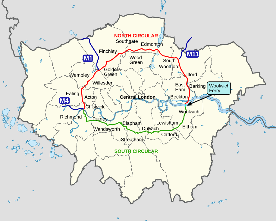
| Beskrivelse | An outline map of the North Circular and South Circular roads, including the Woolwich Ferry linking the two. |
| Dato | |
| Kilde | Eget verk |
| Opphavsperson | Cnbrb |
Lisensiering
| Jeg, opphavsrettensholderen til dette verket, frigir dette verket til allmennheten. Dette gjelder på verdensbasis. I enkelte land kan dette være juridisk umulig. I så fall: Jeg gir hvem som helst retten til å bruke dette verket for ethvert formål, uten noen vilkår, med mindre slike vilkår kreves ved lov. |
Filhistorikk
Klikk på et tidspunkt for å vise filen slik den var på det tidspunktet.
| Dato/klokkeslett | Miniatyrbilde | Dimensjoner | Bruker | Kommentar | |
|---|---|---|---|---|---|
| nåværende | 29. okt. 2022 kl. 13:45 | | 4 542 × 3 809 (46 KB) | Hanif Al Husaini | Lighten background to make higher contrast with the green text and line for the South Circular |
| 13. mai 2019 kl. 03:17 |  | 4 542 × 3 809 (46 KB) | MetrolandNW | Further pinpoint fixes for accuracy, added other notable places | |
| 12. mai 2019 kl. 00:00 |  | 4 542 × 3 809 (43 KB) | MetrolandNW | Fixes for place names (now mentions major places near/on the roads), corrected words' locations for accuracy ('Friern Barnet' especially was extremely unaccurate), coloured 'NORTH CIRCULAR' and 'SOUTH CIRCULAR' (to their respective lines' colours) | |
| 25. mar. 2008 kl. 00:15 |  | 4 542 × 3 809 (39 KB) | Cnbrb | {{Information |Description=An outline map of the North Circular and South Circular roads, including the Woolwich Ferry linking the two. |Source=self-made |Date=2008-03-24 |Author= Cnbrb |Permission= |other_versions= }} | |
| 25. mar. 2008 kl. 00:01 |  | 4 542 × 3 809 (40 KB) | Cnbrb | {{Information |Description=An outline map of the North Circular and South Circular roads, including the Woolwich Ferry linking the two. |Source=self-made |Date=2008-03-24 |Author= Cnbrb |Permission= |other_versions= }} |
Filbruk
De følgende 2 sidene bruker denne filen:
Global filbruk
Følgende andre wikier bruker denne filen:
- Bruk i en.wikipedia.org
- Bruk i ga.wikipedia.org
- Bruk i simple.wikipedia.org
- Bruk i uk.wikipedia.org
- Bruk i www.wikidata.org