Fil:Laurie island map-en.svg

Størrelse for denne PNG-forhåndsvisningen av denne SVG-filen: 800 × 420 piksler Andre oppløsninger: 320 × 168 piksler | 640 × 336 piksler | 1 024 × 537 piksler | 1 280 × 672 piksler | 2 560 × 1 343 piksler | 867 × 455 piksler.
Opprinnelig fil (SVG-fil, standardstørrelse 867 × 455 piksler, filstørrelse: 133 KB)
| Denne filen er fra Wikimedia Commons og kan brukes av andre prosjekter. Informasjonen fra filbeskrivelsessiden vises nedenfor. |
Beskrivelse
| Beskrivelse |
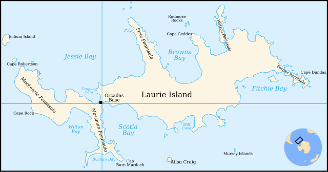
English: Map of Laurie Island, South Orkney Islands |
| Dato | |
| Kilde | Translation of File:Laurie island map-fr.svg |
| Opphavsperson | Original by Pinpin, translated to English by 4ing |
| Andre versjoner | In French: File:Laurie island map-fr.svg |

|
Denne SVG-fila inneholder tekst som enkelt kan oversettes til andre språk. Lær mer. For SVG-bilder kan du benytte [toolforge:svgtranslate/File:Laurie_island_map-en.svglink denne sida] for å oversette teksten til et annet språk. |
Lisensiering

|
Det tillates at dette dokumentet kopieres, distribueres og/eller modifiseres under retningslinjene som beskrevet i GNU fri dokumentasjonslisens, versjon 1.2 eller senere utgave utgitt av Free Software Foundation; med alle seksjoner, uten noen forsidetekster og baksidetekster. En kopi av lisensen er inkludert i avsnittet GNU Free Documentation License. |
| Denne filen er lisensiert under lisensen Creative Commons Navngivelse-DelPåSammeVilkår 3.0 Unported | ||
| Navngivelse: Pinpin and 4ing | ||
| ||
| Dette lisensmerket ble lagt til filen som del av lisensoppdateringen av GFDL. |
Filhistorikk
Klikk på et tidspunkt for å vise filen slik den var på det tidspunktet.
| Dato/klokkeslett | Miniatyrbilde | Dimensjoner | Bruker | Kommentar | |
|---|---|---|---|---|---|
| nåværende | 4. jan. 2011 kl. 23:29 | | 867 × 455 (133 KB) | 4ing | == {{int:filedesc}} == {{Information |Description={{en|1=Map of Laurie Island, South Orkney Islands}} |Source=Translation of File:Laurie island map-fr.svg |Author=Original by Pinpin, translated to English by 4ing |Date=2 |
Filbruk
De følgende 2 sidene bruker denne filen:
Global filbruk
Følgende andre wikier bruker denne filen:
- Bruk i be.wikipedia.org
- Bruk i bg.wikipedia.org
- Bruk i ceb.wikipedia.org
- Bruk i de.wikipedia.org
- Laurie Island
- Orcadas-Station
- Scotia Bay
- Mossman-Halbinsel
- Wilton Bay
- Mackenzie-Halbinsel
- Ailsa Craig (Südliche Orkneyinseln)
- Kap Anderson
- Mill Cove
- Valette Island
- Baldred Rock
- Graptolite Island
- Fitchie Bay
- Ferrier-Halbinsel
- Kap Dundas
- Kap Geddes
- Browns Bay (Laurie Island)
- Pirie-Halbinsel
- Rudmose Rocks
- Watson-Halbinsel
- Kap Mabel
- Jessie Bay
- Marr Bay
- Kap Robertson
- Kap Valavielle
- Buchan Bay
- Uruguay Cove
- Bruk i en.wikipedia.org
- Bruk i eo.wikipedia.org
- Bruk i es.wikipedia.org
- Bruk i fi.wikipedia.org
- Bruk i fr.wikipedia.org
- Bruk i he.wikipedia.org
- Bruk i ja.wikipedia.org
- Bruk i ka.wikipedia.org
- Bruk i lld.wikipedia.org
- Bruk i mk.wikipedia.org
- Bruk i nn.wikipedia.org
Vis mer global bruk av denne filen.