Fil:EnglandGovernmentMidlands.png

Størrelse på denne forhåndsvisningen: 486 × 599 piksler. Andre oppløsninger: 195 × 240 piksler | 389 × 480 piksler | 623 × 768 piksler | 830 × 1 024 piksler | 2 165 × 2 670 piksler.
Opprinnelig fil (2 165 × 2 670 piksler, filstørrelse: 100 KB, MIME-type: image/png)
| Denne filen er fra Wikimedia Commons og kan brukes av andre prosjekter. Informasjonen fra filbeskrivelsessiden vises nedenfor. |
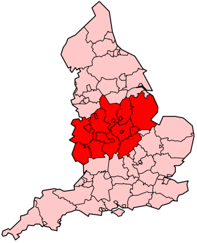
| Beskrivelse | Map showing the two Government Office regions of West Midlands and East Midlands. | ||||||||
| Dato | 14. desember 2005 (original upload date) | ||||||||
| Kilde | Transferred from en.wikipedia to Commons. | ||||||||
| Opphavsperson | Morwen at engelsk Wikipedia | ||||||||
| Tillatelse (Gjenbruk av denne filen) |
Morwen at engelsk Wikipedia, rettighetsinnehaver av dette arbeidet, publiserer det herved under følgende lisens:
|

Filhistorikk
Klikk på et tidspunkt for å vise filen slik den var på det tidspunktet.
| Dato/klokkeslett | Miniatyrbilde | Dimensjoner | Bruker | Kommentar | |
|---|---|---|---|---|---|
| nåværende | 2. mar. 2019 kl. 14:47 | | 2 165 × 2 670 (100 KB) | Inops | Reverted to version as of 19:13, 9 February 2009 (UTC) no doubt, but the point of the map is to show the old governmental regions with "Midlands" in their name. Grimsby has a better claim to be in the Midlands than Norfolk, for example. |
| 25. jan. 2019 kl. 16:13 |  | 2 165 × 2 670 (139 KB) | Rubensbathsheba | The Midlands also sometimes includes the counties of Norfolk, Suffolk, Cambridgeshire, and Huntingdonshire. | |
| 9. feb. 2009 kl. 21:13 |  | 2 165 × 2 670 (100 KB) | Isthmus | {{Information |Description=Map showing the two Government Office regions of West Midlands and East Midlands. |Source=Transferred from [http://en.wikipedia.org en.wikipedia]. |Date=2005-12-14 (original upload date) |Author=Morwen at [ht |
Filbruk
Den følgende siden bruker denne filen:
Global filbruk
Følgende andre wikier bruker denne filen:
- Bruk i ar.wikipedia.org
- Bruk i bg.wikipedia.org
- Bruk i br.wikipedia.org
- Bruk i ca.wikipedia.org
- Bruk i en.wikipedia.org
- Bruk i es.wikipedia.org
- Bruk i eu.wikipedia.org
- Bruk i fa.wikipedia.org
- Bruk i ga.wikipedia.org
- Bruk i id.wikipedia.org
- Bruk i it.wikipedia.org
- Bruk i ko.wikipedia.org
- Bruk i lt.wikipedia.org
- Bruk i mk.wikipedia.org
- Bruk i ro.wikipedia.org
- Bruk i sh.wikipedia.org
- Bruk i sr.wikipedia.org
- Bruk i sv.wikipedia.org
- Bruk i ta.wikipedia.org
- Bruk i tr.wikipedia.org
- Bruk i vi.wikipedia.org
- Bruk i www.wikidata.org
- Bruk i zh.wikipedia.org