Fil:Clerkenwell 1805 Cartographer; Tyrer, James.jpg

Opprinnelig fil (712 × 758 piksler, filstørrelse: 253 KB, MIME-type: image/jpeg)
| Denne filen er fra Wikimedia Commons og kan brukes av andre prosjekter. Informasjonen fra filbeskrivelsessiden vises nedenfor. |
Beskrivelse
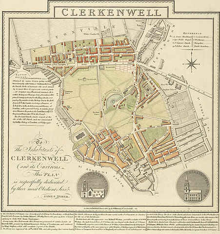
A plan of Clerkenwell in London by James Tyrer, 1805. The old part of Clerkenwell, which lies immediately to the north of the City of London, is at the bottom of the map. Development has occurred along much of Clerkenwell's north-axis of St John Street. The then recently developed Pentonville, which lay in the parish of Clerkenwell, but was otherwise more closely connected with Islington (which was a separate parish and is shown in part in grey at the top right) is at the top of the map.
Lisensiering
|
Dette verket er offentlig eiendom i Norge, EU og land der den opphavsrettslige vernetiden etter opphavsmannens død er 70 år eller kortere. Merk at noen land har lengre vernetid.
| |
| Denne filen har blitt identifisert til å være fri for kjente restriksjoner under lov om opphavsrett, inkludert alle relaterte og nærstående rettigheter. | |
Filhistorikk
Klikk på et tidspunkt for å vise filen slik den var på det tidspunktet.
| Dato/klokkeslett | Miniatyrbilde | Dimensjoner | Bruker | Kommentar | |
|---|---|---|---|---|---|
| nåværende | 16. feb. 2006 kl. 02:14 | | 712 × 758 (253 KB) | Merchbow~commonswiki | A plan of Clerkenwell in London by James Tyrer, 1805. The old part of Clerkenwell, which lies immediately to the north of the City of London, is at the bottom of the map. Development has occurred along much of Clerkenwell's north-axis of St John Street. T |
Filbruk
Den følgende siden bruker denne filen:
Global filbruk
Følgende andre wikier bruker denne filen:
- Bruk i ar.wikipedia.org
- Bruk i en.wikipedia.org
- Bruk i fi.wikipedia.org
- Bruk i it.wikipedia.org
- Bruk i vi.wikipedia.org