Fil:Ash and Steam Plume, Soufriere Hills Volcano, Montserrat.jpg
Opprinnelig fil (2 598 × 2 039 piksler, filstørrelse: 1,61 MB, MIME-type: image/jpeg)
| Denne filen er fra Wikimedia Commons og kan brukes av andre prosjekter. Informasjonen fra filbeskrivelsessiden vises nedenfor. |
Beskrivelse
| Beskrivelse |
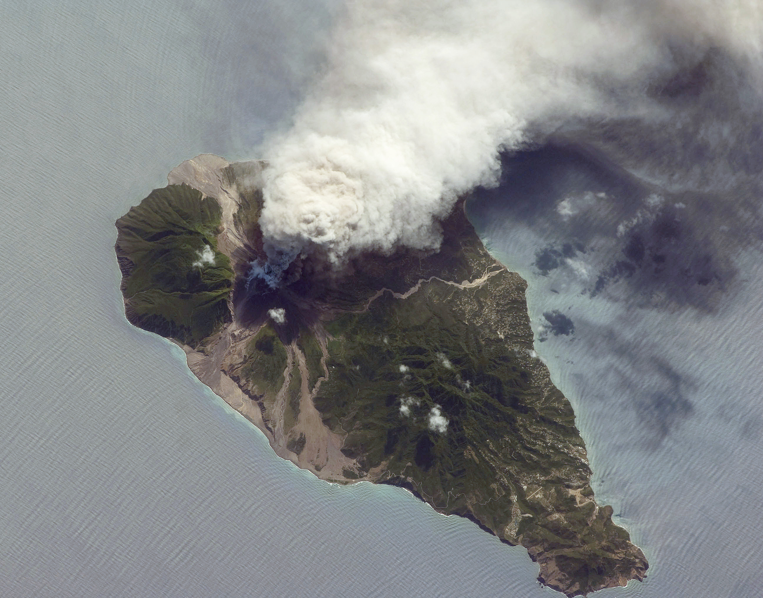
English: This oblique astronaut photograph from the International Space Station (ISS) captures a white-to-grey ash and steam plume extending westwards from the volcano. Oblique images are taken by astronauts looking out from the ISS at an angle, rather than looking straight downward toward the Earth (a perspective called a nadir view), as is common with most remotely sensed data from satellites. An oblique view gives the scene a more three-dimension quality, and provides a look at the vertical structure of the volcanic plume. While much of the island is covered in green vegetation, grey deposits that include pyroclastic flows and volcanic mud-flows (lahars) are visible extending from the volcano toward the coastline. When compared to its extent in earlier views, the volcanic debris has filled in more of the eastern coastline. Urban areas are visible in the northern and western portions of the island; they are recognizable by linear street patterns and the presence of bright building rooftops. The silver-grey appearance of the Caribbean Sea surface is due to sun-glint, which is the mirror-like reflection of sunlight off the water surface back towards the hand-held camera on-board the ISS. The sun-glint highlights surface wave patterns around the island.
|
||||||||||||||||||||||||||||||||||||||||||||||||||||||
| Dato | |||||||||||||||||||||||||||||||||||||||||||||||||||||||
| Kilde | NASA Earth Observatory | ||||||||||||||||||||||||||||||||||||||||||||||||||||||
| Opphavsperson | Image taken by the NASA Expedition 21 crew | ||||||||||||||||||||||||||||||||||||||||||||||||||||||
| Kameraposisjon | | Dette og andre bilder på denne posisjonen på: OpenStreetMap |
|---|
This image or video was catalogued by Johnson Space Center of the United States National Aeronautics and Space Administration (NASA) under Photo ID: ISS021-E-5555. This tag does not indicate the copyright status of the attached work. A normal copyright tag is still required. See Commons:Licensing. Other languages:
|
Image acquired with a Nikon D2Xs digital camera fitted with a 400 mm lens, and is provided by the ISS Crew Earth Observations experiment and Image Science & Analysis Laboratory, Johnson Space Centre.
Lisensiering
| This file is in the public domain in the United States because it was solely created by NASA. NASA copyright policy states that "NASA material is not protected by copyright unless noted". (See Template:PD-USGov, NASA copyright policy page or JPL Image Use Policy.) | ||
 |
Warnings:
|
Filhistorikk
Klikk på et tidspunkt for å vise filen slik den var på det tidspunktet.
| Dato/klokkeslett | Miniatyrbilde | Dimensjoner | Bruker | Kommentar | |
|---|---|---|---|---|---|
| nåværende | 19. okt. 2009 kl. 12:26 | | 2 598 × 2 039 (1,61 MB) | Originalwana | {{Information |Description={{en|1=This oblique astronaut photograph from the International Space Station (ISS) captures a white-to-grey ash and steam plume extending westwards from the |
Filbruk
Den følgende siden bruker denne filen:
Global filbruk
Følgende andre wikier bruker denne filen:
- Bruk i de.wikipedia.org
- Bruk i el.wikipedia.org
- Bruk i en.wikiversity.org
- User:Marshallsumter/Radiation astronomy1/Planets/Sciences
- Draft:Keynote lectures/Satellites for radiation astronomy
- Draft:Original research/Astrogeology
- Planets/Geology
- User:Marshallsumter/Radiation astronomy2/Rocks
- Gases/Gaseous objects/Earth
- Radiation/Astronomy
- User:Marshallsumter/Radiation astronomy2/Satellites
- User:Marshallsumter/Radiation astronomy2/Reflections
- User:Marshallsumter/Radiation astronomy/Earth
- Orbital platforms
- Bruk i fr.wikipedia.org
- Bruk i hy.wikipedia.org
- Bruk i oc.wikipedia.org
- Bruk i ru.wikipedia.org