Fil:1842 A new map of Michigan with its canals roads distances by H.S. Tanner.jpg

Størrelse på denne forhåndsvisningen: 469 × 600 piksler. Andre oppløsninger: 188 × 240 piksler | 375 × 480 piksler | 601 × 768 piksler | 801 × 1 024 piksler | 1 602 × 2 048 piksler | 3 352 × 4 286 piksler.
Opprinnelig fil (3 352 × 4 286 piksler, filstørrelse: 11,62 MB, MIME-type: image/jpeg)
| Denne filen er fra Wikimedia Commons og kan brukes av andre prosjekter. Informasjonen fra filbeskrivelsessiden vises nedenfor. |
Beskrivelse
| Beskrivelse |
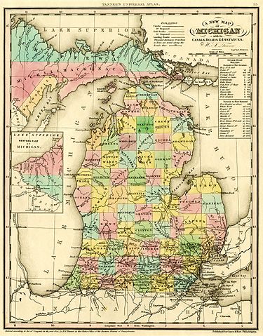
English: A new map of Michigan with its canals, roads & distances / by H.S. Tanner ; engd. by E.B. Dawson. Philadelphia : Carey & Hart, [1842].
Scan of a map in the collection of the Michigan State University Map Library. Original map was detached from an atlas published in 1842: A new universal atlas. Philadelphia : Carey & Hart, 1842. MSU Libraries catalog record: http://catalog.lib.msu.edu/record=b12049211~S39a The map shows early names (assigned 1840) of northern Michigan counties, many of which were renamed in 1843. Some of these names are misspelled: Correct spelling / Name on map:
|
|||||||||||||||||||
| Dato | 1842, ©1841 | |||||||||||||||||||
| Kilde | http://www.lib.msu.edu/branches/map/MiJPEGS/843-D-1842-Tanner/ | |||||||||||||||||||
| Opphavsperson |
|
|||||||||||||||||||
Lisensiering
This media file is in the public domain in the United States. This applies to U.S. works where the copyright has expired, often because its first publication occurred prior to January 1, 1929, and if not then due to lack of notice or renewal. See this page for further explanation.
|
 | |
 |
This image might not be in the public domain outside of the United States; this especially applies in the countries and areas that do not apply the rule of the shorter term for US works, such as Canada, Mainland China (not Hong Kong or Macao), Germany, Mexico, and Switzerland. The creator and year of publication are essential information and must be provided. See Wikipedia:Public domain and Wikipedia:Copyrights for more details.
|
Filhistorikk
Klikk på et tidspunkt for å vise filen slik den var på det tidspunktet.
| Dato/klokkeslett | Miniatyrbilde | Dimensjoner | Bruker | Kommentar | |
|---|---|---|---|---|---|
| nåværende | 5. okt. 2016 kl. 21:04 | | 3 352 × 4 286 (11,62 MB) | TimK MSI | cropped |
| 5. okt. 2016 kl. 21:03 |  | 4 095 × 5 296 (7,33 MB) | TimK MSI | {{Information |Description ={{en|1=A new map of Michigan with its canals, roads & distances / by H.S. Tanner ; engd. by E.B. Dawson. Philadelphia : Carey & Hart, [1842]. Scan of a map in the collection of the Michigan State University Map Library.... |
Filbruk
Det er ingen sider som bruker denne filen.
Global filbruk
Følgende andre wikier bruker denne filen:
- Bruk i en.wikipedia.org